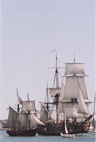
Showing posts with label Australia.. Show all posts

Thursday, November 22, 2007

FRIDAY'S HISTORY POST: OCEAN GROVE

This is one of the oldest buildings in Ocean Grove. This photograph taken in 1977.[Photograph from the Ocean Grove Album compiled by Bob Irving, courtesy of John Irving, Ocean Grove]


Map of where Ocean Grove is situated to the CBD.
I thought it apt to speak of the History surrounding the lovely place we go to so often to share in fun family times, and sucha relaxing place it is. Approximately 50 minutes drive away from our house you will find yourself entering this wonderful place. Just crossing the bridge from Barwon Heads to Ocean Grove is the most magical sight...second for myself to that of the sun setting into the Ocean (it would seem) when in W.A. at Freemantle.


So... Ocean Grove, it is named after a place in New Jersey, USA. During the 1870s the American Methodist church started a religious camp near New Jersey, it was such a successful idea they decided to spread there camps overseas. Soon they got together with the Victorian Methodists and set up a camp near Point Lonsdale ( a lovely place near Ocean Grove).
By 1882 the need arose for the church to acquire a large area of land so they could set up their "Australian Ocean Grove".

Ocean Grove State School in 1910 showing Mr. Hugh Clark and pupils. Hugh Clark taught at the school for almost 30 years and was Head Teacher from 1911 until 1925.
[Photograph from the Ocean Grove Album compiled by Bob Irving, courtesy of John Irving, Ocean Grove]
The place the Methodists chose was was situated on the east side of the mouth of the Barwon River overlooking Bass Strait. The town was later linked by a bridge to Barwon Heads on the other side of the river. Many street names take on the names of important people in the old Methodist community, while the local youth camp was run by the Methodist church from the 1920s up until 1996. Down Main Street Ocean Grove.
Now the largest town on the Bellarine Peninsula it has one of the largest shopping centres of any of the Bellarine towns only a few blocks from the beach making it popular with tourists and locals alike. There are groovy little cafes and some awesome clothes shops in Ocean Grove. Yet, the major draw card is, of course, the beach.

Friday, November 16, 2007

FRIDAYS HISTORY POST: Phar Lap: Australia's wonder horse

He triumphed during the Great Depression of the early 1930s, when a hero was most needed by the people of Australia.
He conquered the local racing scene—36 wins from his last 41 starts—and then won North America's richest race, the Agua Caliente Handicap, in 1932.
A fortnight later he went to the great equine heaven in the skies, struck down by a mystery illness that many suspected was the work of gangsters. The horse traveled with security guards to protect his safety. Gunshots were allegedly fired at the champion after one morning gallop.
For the history of Pharlap, click THIS LINK, complete with 1930's music, you will see the amazing horse that once stopped a nation.
His heart has been on display for many years in a museum. Why, I hear you ask? Because a normal horses' heart weights approximately 4 kilograms and Pharlap's was 6.2 kilograms. So amazing!
For a look at the film starring Pharlap, you can watch this clip also, accompanied again by wonderful music.

Thursday, November 01, 2007

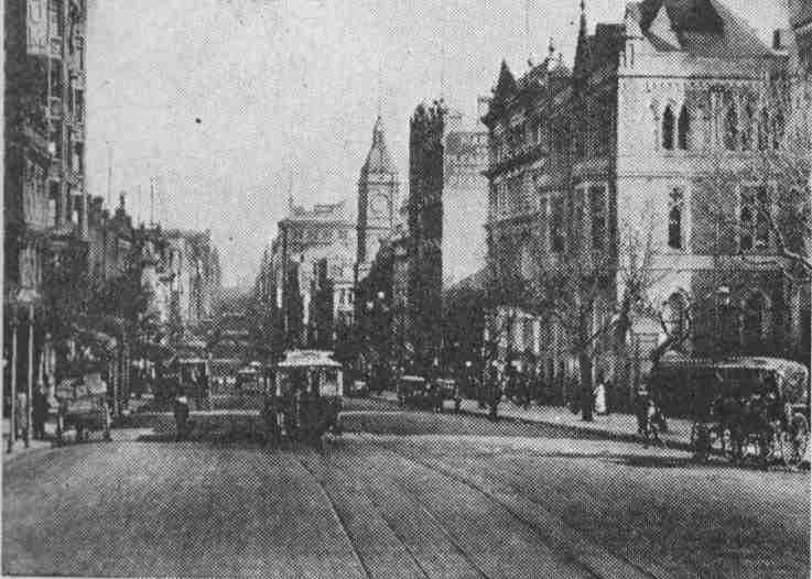
FRIDAYS HISTORY LESSON: Collins Street Melbourne.

Collins Street in the early 1900's (courtesy of Rail Page)

Collins Street is a major street in the Melbourne central business district and runs approximately east to west.
It is notable as Melbourne's best known street, with some of the country's finest Victorian era buildings.
Known as The 'Paris end' of Collins Street, the Eastern end is a part of Marvellous Melbourne mythology. Although modern development has destroyed some of the European flavour of the top-end of Collins Street it still retains designer boutiques and cafes. The length of Collins Street between Elizabeth and King Streets has long been the financial heart of Melbourne and is home to banks and insurance companies.

One of the most breath taking buildings in Melbourne, if not on the outside, is probably 333 Collins Street Melbourne. The Atrium is one place you have got to see to believe. And, for your viewing pleasure, click HERE for a taste of it virtually. See...it does not disappoint.
Collins Street is named after Lieutenant-Governor David Collins who led a group of settlers in establishing a short-lived settlement at Sorrento on the Mornington Peninsula south of Melbourne in the early 1800s. He subsequently became the first governor of the colony of Van Diemens Land, later to be renamed Tasmania.
Festive time at The Block Arcade.
Around the turn of the century "doing the Block" became a pastime for shoppers at the Block Arcade area in the retail heart of the street between Elizabeth and Swanston Streets.
The Bank of New South Wales Melbourne office earned architect Joseph Reed a first prize in architecture. When the building was demolished in 1935, the facade was transferred to the University of Melbourne to become the Commerce building, (now administration for the Faculty of Architecture, Building and Planning)
During the 1950s and 1960s, the street became subject to extensive redevelopment and many historic buildings were demolished by Whelan the Wrecker, despite the efforts of the National Trust and the "Save Collins Street" group. While some examples of boom style architecture survive, the grandest examples were lost to the wrecker's ball. Of the major losses, the most significant were the large Victorian buildings including the Federal Coffee Palace, Colonial Mutual Life building, Robb's buildings, Queen Victoria Buildings, City of Melbourne Bank, Scott's Hotel, Melbourne Mansions and APA building.
Between 2003-2005, Collins Street was extended west beyond Spencer Street, and currently ends in plastic barriers and a T intersection with Stadium Drive. It is expected to extend further west in the future, as part of the new Docklands redevelopment. This will create an intersection between Bourke Street and Collins Streets, two of Melbourne's most important streets.
One of our top tourist attractions is the Rialto Towers pictured above. Standing at 251 m (824 ft), this allows visitors to have a birds eye view of Melbourne, our Port Phillip Bay and, if it is a clear day, you can see as far as The Dandenong Ranges.
There are also many gorgeous churches along the street, and if you take some time out to walk along and really look at each building you may find some treasures there..even if you have lived here for ages, sometimes things can go unnoticed. Oh, and if your feet get weary, don't fret, you can just hop on board a tram!

Thursday, October 25, 2007

Friday's History Lesson: Station Pier, Port Melbourne...

Station Pier Today

Station Pier in the year 1910. Immigrants arriving in Melbourne.

History of Station Pier : Originally called Railway Pier, it was officially opened on 12 September 1854 and the 150th anniversary was celebrated in September 2004.
The pier played a pivotal role in Victorians’ lives from the time it was opened, particularly for the arrival of gold seekers and settlers throughout the mid to late 1800s.
In 1861, the original pier was extended, to more than 661 metres (2171 feet). Eventually, the original pier could not accommodate the increasingly large and more powerful steamships of the early twentieth century so it was realigned, extended further and renamed Station Pier.
The pier is heritage listed and the gatehouse at the entrance is of significant heritage and cultural importance.


The Gatehouse, Station Pier.
Comings and goings: In August 1899, the first contingent of troops headed for the Boer War in South Africa left from Station Pier. In October 1914, 16 ships left Port Melbourne carrying troops, horses and supplies as part of Australia’s contingent for the Great War (World War I). Station Pier was also the place of return for the military hospital ships.

HMS IMPLACABLE, FEB 1946

The 1940s saw many troops embark for the Middle East, Britain and Singapore for World War II service.
Station Pier is intrinsically linked to Melbourne’s rich multicultural society with an average 61,000 overseas passengers arriving on an annual basis in Port Melbourne between 1949 and 1966. For many post-World War II immigrants Station Pier symbolises where their new life began.

HMAS Doomba, 1940. This ship was a training vessel aswell as a minesweeper.

Today, the pier has more than 500,000 local, interstate and overseas visitors, including migrant family and friends' reunions.

There is so much romance involved in the history of shipping, in the history of what went on, and what goes on today beside the waters at Station Pier. You really have to be there to acknowledge the fact. Sit, have a coffee, enjoy some seafood from some of the fine eateries just down from the Pier and observe....you won't be disappointed!

Friday, October 05, 2007

FRIDAY'S HISTORY POST: SAILOR'S FALLS.


Today my cousin met up with me at Sailor's Falls. This is where we exchanged kids...you know, Tomas went to her place up the bush and her little girl who is my Nicholas' age came to stay and entertain my other three kiddies.
This place is just such a hidden treasure. If you were not truly searching for it you would all but drive right by it.
Situated about 50 minutes drive out of Melbourne, towards the lovely Mineral Springs area of Dayelsford is Sailor's Falls. 5 kilometres shy of Dayelsford to be exact. Sailor' Falls was originally known as Tunnel Falls(More about that later).
The story behind the name of this magical place is that there was once a group of sailors who jumped ship in the 1850's. They had come to Australia to seek their fortune in the Gold Rush. They discovered this lovely creek an tried their fortune at mining the stream. What they did discover was that this creek ran into a 15metre drop water fall, and that the area was indeed rich in minerals.
Sodium Bicarbonate waters can be found in the Northern Spring Outlet.
In the 1850's, Miners tunneled in beneath the waterfalls for the rich content of the various rock formations. Sub-basaltic deep lead alluvial sediments to be exact. The tunnel and trestle supports were still present below the falls up until the 1920's.

Now, the place i a lovely picnic place and a loos top. You can walk right down to the falls and there are many tracks to go for long all day walks from the picnic area itself.
See, the magic is in the eyes of the beholder...and the smell..... naturally glorious!

Thursday, August 30, 2007

FRIDAY'S HISTORY LESSON:The City of Geelong.

Geelong is the second largest city in the state of Victoria, Australia and is the largest regional centre in the state. It is a port city with an urban population of approximately 161,000 people. Also it is one of the largest provincial cities in Australia. Geelong is located on Corio Bay, 75 kilometres south-west of the state's capital, Melbourne.
The city is a gateway to many renowned tourist attractions, namely the scenic Great Ocean Road, the Shipwreck Coast and the Bellarine Peninsula.
The explorers Hamilton Hume and William Hovell. They reached Corio Bay - the area of Port Phillip Bay that Geelong now fronts - on 16 December 1824, and it was at this time they reported that the Aborigines called the area Corayo, the bay being called Jillong (Hence the places now known as Cario and Geelong). Hume and Hovell had been contracted to travel overland from Sydney to Port Phillip, and having achieved this they stayed the night and begun their return journey the following day. William Buckley, an escaped convict from the Sullivan Bay settlement, lived among the Wautharong people for 32 years in the Bellarine Peninsula. Sighting of an old ship on Cario Bay.

1840 saw the first issue of The Geelong Advertisor Newspaper which still runs print today. 1850's saw the Goldrush increase population in Geelong from 8,000 to approximately 22,000. The port access a clear advantage.

The town of Geelong officially became a city on 8 December 1910. Electric trams began operation in 1912, travelling along Pakington St, Geelong West and the city centre until their demise in 1956.
Electric Car TRam Geelong 1912.


Between 1922 and 1925 Geelong's industrial growth began: three woollen mills, fertilizer plants and the Ford Motor Company's vehicle plant at Norlane. The Corio whiskey distillery (1928) and the Geelong Advertiser's radio station 3GL (now K-Rock) (1930) were opened.

Now Geelong is a popular Summer vacation spot and has everything you would wish for as a couple or as a family. Theme parks, the waters edge, carnivals, restaurants, museums and, if you don't fancy driving to Geelong there is a V-Line train service that can get you there from Melbourne. Remember our family train trip to Geelong recently?

Fond memories of wading in the water at Eastern Beach and eating ice cream and riding the old carousel ( manufactured in 1892) are mine to keep and yours to make!

Friday, March 09, 2007

Friday History Lesson Number....2.

If you ever come to Victoria, The Great Ocean Road is one trip you need to take. Covering the coastline of South West Victoria, The Great Ocean Road takes you through some great townships all boasting different tourist attractions, not to mention the drive in between them that has breathtaking scenery.

The road was built between 1919 and 1932 by more than 3000 returned soldiers in honour of their comrades who fell in the First World War.That makes it the world’s biggest war memorial!! This year is the 75th anniversary of the road, and there are plans to unveil a sculpture. Apparently, it will capture the spirit of the men who built the road, with one of the life-sized figures handing his mate a drink bottle. Building the road with pick and shovel would have been hard work and it would have been thirsty work.

The Road takes you where you can view some pretty rough and rugged cliffs and bluffs. It begins at Barwon Heads and ends at Warnambool.


Stop off at the Twelve Apostles( pictured above), Tour through the lovely Otway Ranges, stop at Torquay, Lorne and Apollo Bay, see the historic villages of Queenscliff, Port Campbell, Portland and Port Fairy. Not forgetting the town of Warnambool.
I have worked with many nurses over the years who come over from another country and save their hard earned money and then buy a van and go travel this road. They take a few weeks so they can see everything possible along the way. They are never disapointed!!
So there you have it, another lesson given to all my blogmates, another tribute to our wonderful and brave returned servicemen, otherwise known as "diggers".


Friday, March 02, 2007

Friday History Lesson...Number 1

In reading a blog called Old Dog New Trick, Betty gave me an idea for a post...originally, she didn't have an idea for a post and it turned into one of the best I have read!! It was about her trip to Northern California. Betty spoke of the people's love of their trees, how they are named and made into tourist attractions.

So it made me want to write about something very special here inAustralia. We too have memorial trees, these are for our fallen soldiers from WW1. In the township of Lakes Entrance in Victoria, there was an Avenue of Honour of Monterey Cypress Trees planted ( in 1924). This was to remember the 26 local men that were killed in that war.

Story goes that some of the trees were removed for various reasons over the years and back in 1997 the council was going to remove the remainder, with much upheaval from the local community.

Following a public campaign by the Lakes Entrance Regional Historical Society the trunks of six of the trees have been preserved and transformed into memorial sculptures by chainsaw artist John Brady. These sculptures are regularly waxed and oiled to preserve the wood.

Wounded Soldier and Donkey. CARVED BY JOHN BRADY, JUNE 1998.

Family waiting for dad. Carved by John Brady, Feb 1999.


WW1 Nurse. CARVED BYJOHN BRADY, AUG 1998.

SIMPSON* HELPING A WOUNDED SOLDIER TO WHERE HIS DONKEY AND ANOTHER PATIENT WAITS CARVED BY JOHN BRADY, SEPT 1998.

Soldier WWI SOLDIER byJOHN BRADY, MAY 1998.

Each sculpture has a plaque attached similar to:THESE SCULPTURES HONOUR THE MEMORY OF FIRST WORLD WAR DEAD AND INJURED PLEASE TREAT THEM WITH RESPECT LAKES ENTRANCE R.S.L.

* Private John Simpson Kirkpatrick was a stretcher bearer on Gallipoli who used a donkey to rescue wounded soldiers.

So there you have it, a small history lesson for everyone. Have a wonderful and safe weekend my friends :)